
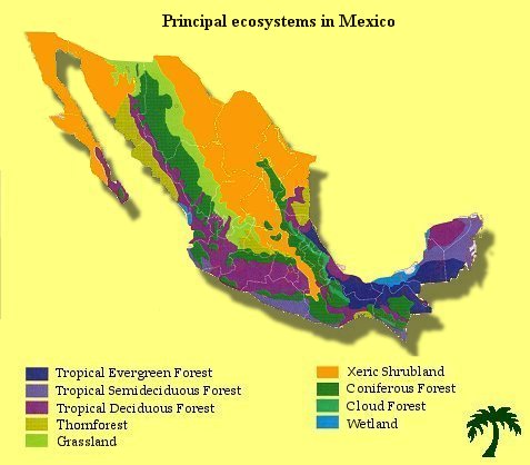
Principal ecosystems in Mexico
One of the most complex and richest ecosystems on the Earth. It has been
estimated that more than 50% of all animal and plant species live here.
Occurs in lowland areas (below 1200m) of abundant precipitation and year
round warmth with mean monthly temperatures higher than 18 degrees Celsius
(usually in between 20 and 28 degrees Celsius). The yearly precipitation
is usually higher than 250 cm (150 - 400cm) and can be slightly unevenly
distributed. More than 75% of species maintain their leaves all year round.
This ecosystem shows distinctive vertical
stratification:
A layer - the emergents:
Widely spaced trees 30 to 40m tall and with umbrella-shaped canopies extend
above the general canopy of the forest. Since they must contend with drying
winds, they tend to have small leaves and some species are deciduous during
the brief dry season.
B layer:
a closed canopy of around 25m tall trees. Light is readily available
at the top of this layer, but greatly reduced below it.
C layer:
a closed canopy of 20m tall trees. There is little air movement in this
zone and consequently humidity is constantly high.
Shrub/sapling
layer:
Less than 3 percent of the light intercepted at the top of the forest
canopy passes to this layer. Arrested growth is characteristic of young
trees capable of a rapid surge of growth when a gap in canopy above them
opens.
Ground layer:
sparse plant growth. Less than 1 percent of the light that strikes the
top of the forest penetrates to the forest floor. In such darkness few
green plants grow. Moisture is also reduced by the canopy above: one third
of the precipitation is intercepted before it reaches the ground.
These ecosystems are composed of a mixture of deciduous trees and tropical
evergreens and are found below 1200m above sea level. The climate has
distinct wet and dry seasons. It is warm all year round. The length of
the dry season varies according to the location. From 50 to 100% of the
trees lose their leaves (are deciduous) during this time of periodic drought,
as a mechanism to reduce water loss.
The trees here are typically not as close together as in the tropical
rainforests, so more light can reach the forest floor, especially when
the deciduous species have dropped their leaves.
Among the most common plants are species of genus Burseras. Other common
species are Amphipterygium adstringens, Bucida macrostachya, Capparis
incana, Ceiba aesculifolia, Cyrtocarpa procera, Celtis iguanea, Cephalocereus
hoppenstedtii, Pachycereus weberi, Neobuxbaumia tetetzo, Agave potatorum
y Agave marmorata.
Natural forest with > 30% canopy cover, below 1200m altitude, in which
the vegetation is composed of thorny shrubs, bushy trees, a few sparsely
scattered tall trees, and little or no grass, succulent phanerophytes
with thorns may be frequent. The dry season usually extends for 6 -7 months.
The annual precipitation averages 50 to 70 cm.
The most common tree species are Amphipterygium adstringens,
Mimosa eurycarpa, Cercidium praecox, Prosopis juliflora ect.
Occurs usually in regions with slightly undulating topography. The predominant vegetation is low, between 60 and 90 cm. The dry season is pronounced and long, from 6 -9 months. The annual mean temperature can range from 12 to 20C and mean annual precipitation from 30 -60 cm. The predominant species belong to genus Bouteloa, Acacia, Agave, Quercus, Zinnia, etc.
Ecosystem
with thorny and deciduous elements, composed mainly of small -leaf
bushes and characteristic for its tower -like cacti. The daily temperatures
can be very extreme, reaching 42C and the diurnal changes are typically
very big (frequently 20C).The mean annual temperature ranges from 12 to
26C. Xeric shrublands occur in wide range of altitudes, from the sea level
to 2200 metres.
The mean annual precipitation is generally lower than 70 cm.
In areas covered with tower -like cactus species these following species
can be found: Cephalocereus chrysacanthus, Pachycereus weberi, Myrtillocactus
geometrizans, Escontria chiotilla, Neobuxbaumia macrocephala, Stenocereus
pruinosus, Pachycereus hollianus.
The typical bush species are Acacia acatlensis, Ceiba parvifolia,
Mimosa lacerata, Brahea dulcis.
As the name suggest, vegetation is composed predominantly of coniferous
trees. The temperatures usually fall bellow freezing point during winter
and can be considerably high in summer. Coniferous forests occur mostly
on the northern hemisphere, where they form the largest biome on the Earth.
Pine forests in Mexico grow at elevations of 2,275-2,600 m and are composed
mainly of Pinus montezumae (Trans Volcanic Belt area), although
in more humid areas, P. pseudostrobus is the dominant species.
In drier areas with more shallow soils, P. rudis and P. teocote
are the dominant elements. At low elevations (below 2,000 m) P. oocarpa
and P. michoacana are more common and are sometimes interspersed
with P. herrerae, P. pringlei and P. leiophylla, along
with some individuals of Quercus. Above 3,000 m throughout the
Trans-Volcanic belt, the forests are a strict combination of Pinus
hartwegii and Abies religiosa. The herbaceous stratum is
well developed and epiphytes are abundant.
Can
be found in humid areas above 1000 m above see level. Trees usually reach
more than 20m. The mean annual temperature varies from 12 to 23C, the
annual mean precipitation is always higher than 100 cm and sometimes exceeds
300 cm. In many cases the forests are enshrouded in semipermanent mist
giving rise to the term cloud forest.
Cloud forests harbor many species that can be found in the rain forests,
but are typically rich in epiphytes, parasitic plants, bromeliads, vines,
ect. The most common species are Oreomunnea mexicana, Ulmus mexicanus,
Weinmannia pinnata, Liquidambar styraciflua, Chiranthodendron pentadactylon,
Nyssa sylvatica, Quercus sororia, Pinus ayacahuite, Hedyosmum mexicanum,
ect.
The Convention identifies 6 wetland systems:
- marine - not influenced by river flows (e.g. coastal lagoons, rocky shores, and coral reefs)
- estuarine - where rivers meet the sea (e.g. deltas, tidal marshes, and mangrove swamps)
- lacustrine - areas of permanent water with little flow (e.g. wetlands associated with lakes)
- riverine - land periodically inundated by river overflow (e.g. wetlands along rivers and streams)
- palustrine - where there is more or less permanent water (e.g. marshes, swamps, and bogs)
- artificial - wetlands created or radically modified by humans (e.g. fish ponds, gravel pits, salt pans)
Back to Mexican Biodiversity